- Press Release
- 2024/09/09
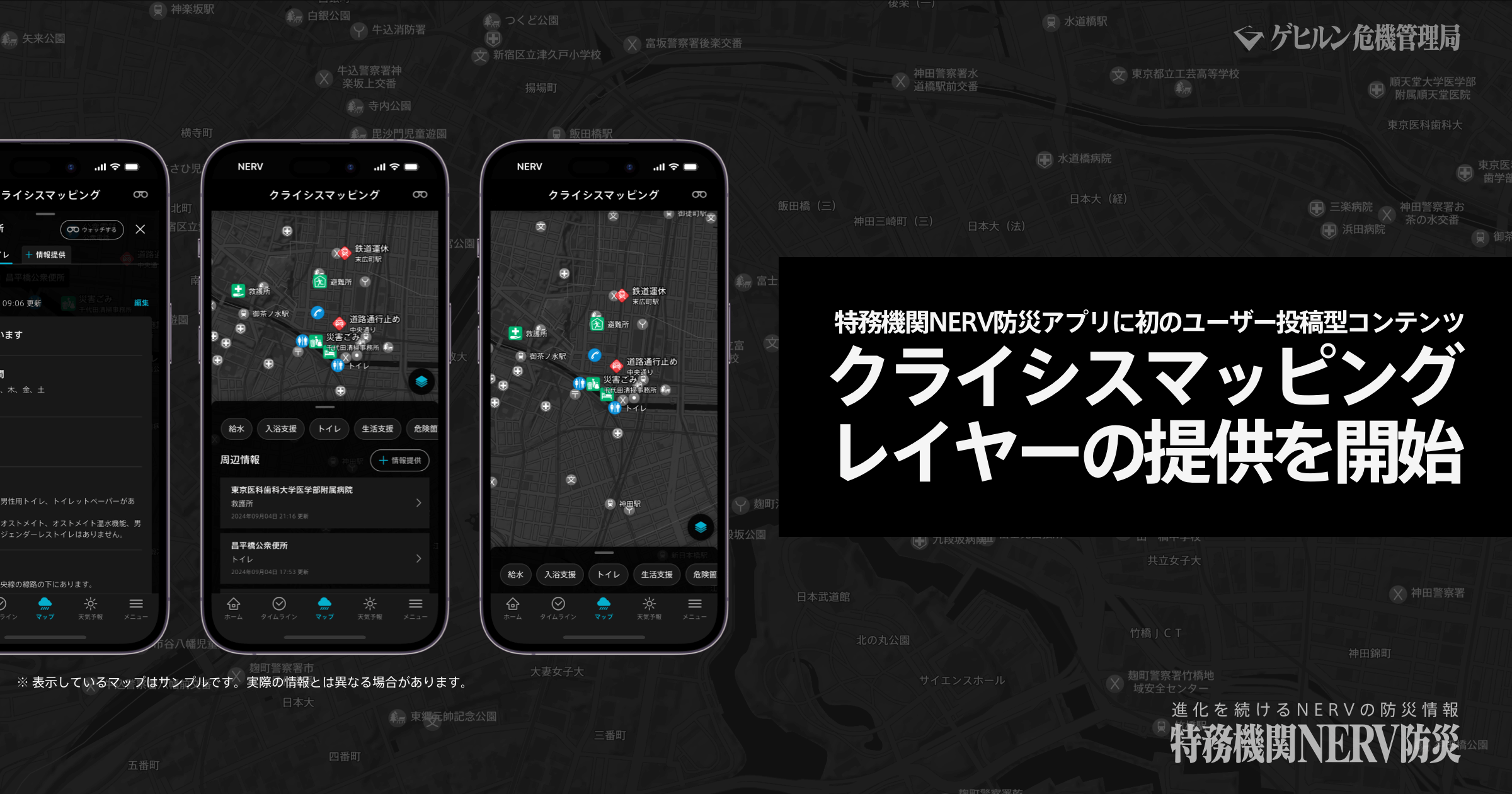
First User-Submitted Content Feature Launched in the NERV Disaster Prevention App: "Crisis Mapping" Layer
Gehirn Inc. (Headquartered in Chiyoda-ku, Tokyo; CEO: Daiki Ishimori; hereinafter referred to as 'Gehirn') has released the version 6.0 update for the "NERV Disaster Prevention App" on September 9th, 2024, implementing the app's first user-submitted content feature, the "Crisis Mapping" layer. The app, which recently marked its 5th anniversary since its release on September 1st, has been downloaded more than 6.2 million times and has over 15,000 Supporters' Club members※1 who continue to support the app's development through a monthly subscription. We would like to extend our heartfelt thanks to all of our users and supporters for their continued support.
What Is The "Crisis Mapping" Layer?
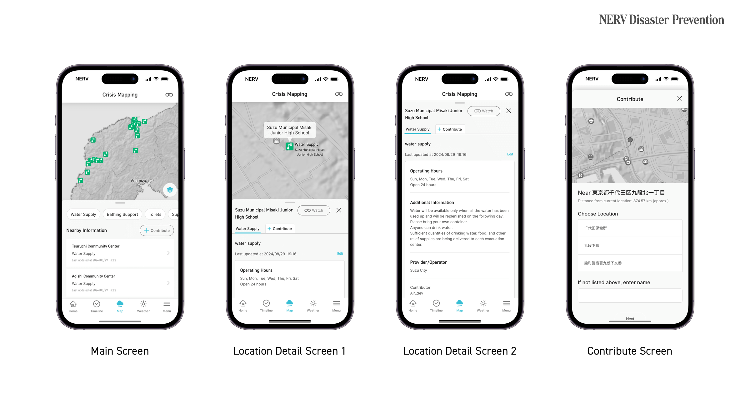
The "Crisis Mapping" layer allows users to visualise and share essential livelihood support information with others during a disaster. This new map layer collects and provides a variety of information vital to rebuilding the lives of disaster survivors, such as the locations of evacuation centres, water supply points, toilet facilities, road conditions, disaster waste collection points, bathing assistance services, disaster certificate application sites, and aid distribution centres.
Posting rights are restricted to Supporters' Club members to ensure the reliability of gathered information. Supporters can post information within a 10km radius of their current location and add detailed explanations※2 where necessary. Incorrect or outdated information can be reviewed by Gehirn, and corrected or deleted by fellow supporters. In addition, Japanese posts are automatically translated into English and vice versa, facilitating information sharing beyond language barriers, aiding international disaster support, and ensuring the safety of foreign residents and visitors to Japan.
This release marks the first phase of this new system, with multiple additional features planned for the future.
"Ever-Evolving Disaster Prevention Information" Ongoing support from over 15,000+ supporters, contributing to the development of new features
In the past 5 years since the app's release in 2019, we've developed various features and strengthened our infrastructure. Each year, we release a major update on September 1st (Disaster Prevention Day), and each press release mentions our goal of "ever-evolving disaster prevention information". Following the launch of the Supporters' Club in 2020, the "Earthquake Early Warning Countdown Forecast" was first made available through Early Access and subsequently released to all users, allowing everyone to benefit from advanced earthquake alerts.
Other features also added include AMeDAS (real-time weather observation) support, snow depth information, typhoon tracking, widgets, volcano-related information such as eruption alerts and ashfall forecasts, weather distribution forecasts, real-time lightning strike observation information, tsunami observation information, and English language support. We also integrated several accessibility features, such as a new light theme, 18 additional accessible colour schemes for colour vision deficiency, and screen reader support. Furthermore, we added support for J-Alert (Civil Protection Information), river level information, synoptic charts, and "Incoming Rain Alerts". The Strong Motion Monitor layer and tremor detection notifications were also added through a mutual cooperation agreement with the National Research Institute for Earth Science and Disaster Prevention (NIED).
In between app updates, we have also been constantly improving the efficiency of our systems and infrastructure, all without interruption to our users. All of these developments have been made possible through the generosity of our Supporters' Club members, who continue to support us through a monthly subscription.
Information to Help Disaster Survivors Rebuild Their Daily Lives
With this 2024 update, we are introducing the app's first user-submitted content feature: the "Crisis Mapping" layer. Until now, we have focused on delivering fast, actionable disaster prevention weather information such as earthquake early warnings, heavy rain risk, and river level information, aiming to provide "information to help people make decisions". However, we have not adequately been able to provide "information to help victims rebuild their daily lives".
The Crisis Mapping layer was developed with the goal of visualising information on the situation in an area after a disaster, particularly information on water supply, bathing assistance services, disaster waste collection sites, and disaster certificate application sites. Some of this information relates to facilities available year-round, while others need to be updated regularly. We can't collect and organise this vast amount of information on our own, but with the help of our supporters, we hope to create a system where everyone can support those affected by disasters.
Development Background and Challenges
Since the Great East Japan Earthquake, the Internet and social media have gained attention as new means of information dissemination. With the rise of smartphones and frequent natural disasters in Japan, many public agencies and media outlets began using social media to publish disaster information. However, the recent shift in social media platforms has led to an explosion of posts aimed at generating impressions or revenue, contaminating the information space and making it difficult to find accurate information. Even for public institutions, challenges such as data format inconsistencies and operational issues have also hindered the effective use of these platforms for seeking information.
In response to this, the team behind the NERV Disaster Prevention App have created a data format specifically for disaster and support information, using Crisis Mapping as a tool to collect and share that information. This project is quite experimental, and the impact of this project on society and how useful or valuable it will be is still unknown to us. There is a possibility that it may not work as intended, but we hope that our network of users can change the way information is communicated.
Crisis Mapping Layer Preview
Anti-Spam Measures
Systems that accept user-submitted content must also fight against potential spam. Many internet services have spent a lot of effort in the past trying to combat spam. For the Crisis Mapping layer, users are limited to only being able to post within a 10km radius of their current location. Posting privileges are also restricted to Supporters' Club members only. Supporters' Club members are users who are committed to contributing to the app's development and maintenance, making them well-suited for this role.
Supporters' Club memberships are also handled through the App Store and Google Play Store, meaning the user must subscribe with their respective Apple or Google accounts. If we suspend a user for posting maliciously, they would need to create a new account with that platform and resubscribe, deterring further spam. If disruptive actions continue despite these measures, we may consider additional steps, such as granting posting rights only after a number of days have passed since joining the Supporters' Club.
Though only Supporters' Club members can post, all users can view the posted information for free.
A Request to All Supporters
Crisis Mapping is only just getting started, and most of the information currently is incomplete. A strong user network is essential for creating high-quality information. We hope that you can map nearby toilets, parks, public facilities, etc., in your area on a regular basis in order to help those around you access essential information in the event of a disaster. Toilet information is particularly important for those who need to know if facilities are accessible or ostomate-friendly (for individuals using a stoma, an artificial opening in the abdomen for waste discharge, such as a colostomy or urostomy).
Just as the app has continued to evolve over the past 5 years, we would be grateful if you could help us grow the still-developing Crisis Mapping layer with us over the years to come.
Gehirn will continue to work on further strengthening the delivery of disaster prevention information.
Overview of the "NERV Disaster Prevention App"
| Name | NERV Disaster Prevention App (Japanese: 特務機関NERV防災アプリ) |
|---|---|
| Official Website | https://nerv.app/en/ |
| Release Date | iOS: 2019/09/01 (Disaster Prevention Day) Android: 2019/12/18 |
| Price | Free |
| Supported OS' | iOS 14 (or newer) Android 7.0 (or newer) |
| Developer | Gehirn Inc.,
|
Access a Wide Range of Disaster Prevention Information in One App
The NERV Disaster Prevention app offers an extensive array of disaster prevention and weather information in just a single app. Receive alerts for real-time earthquake early warnings that show the estimated seismic intensity, propagation of P and S waves, and time until the arrival of shaking at your location. Get notified for earthquake, tsunami, and volcanic eruption bulletins, weather warnings, heavy rain risk, flooding/inundation risk, landslide hazards, and even Civil Protection Information (J-ALERT). View typhoon forecasts, rain cloud radar, river level information and more by manipulating the map on the screen. Zoom in on any location to see information in greater detail or pan across the country to see the rain cloud cover and lightning hotspots of neighbouring cities. You can even view the measured seismic intensity of earthquakes at any scale.
1. Providing Users With the Most Appropriate Disaster Information
Information is displayed based on your current location and pre-registered areas, depending on the priority level assigned to each type of information. We use our own subdivision and mesh data to provide you with the most appropriate information.
2. Push Notifications for Important Information
Critical Alerts, Normal Notifications or Silent Notifications will be issued depending on the user’s location, the type of disaster information, and the level of urgency. If there is an imminent danger and the user must act quickly, like in the case of an Earthquake Early Warning or Tsunami Warning, Critical Alerts get the user’s attention by breaking through the phone’s Silent/Do Not Disturb/Focus modes and sounding at maximum volume.
※ If you do not wish to receive Critical Alerts, you can disable them from the Settings screen. If Critical Alerts are disabled, you will instead receive these notifications as Normal Notifications.
3. Barrier-Free Design
When we began developing the NERV Disaster Prevention app, we implemented various aspects of accessibility from the very beginning and have further improved upon these features over time. As it currently stands, inclusive colour schemes, screen-reader compatibility, contrast adjustment, font thickness and text size are all customisable by the user in order to ensure that information remains accessible to all.
※1 The "NERV Disaster Prevention App Supporters' Club" is a fan club-style system where users who care about the app can pay a monthly fee to support the development and maintenance of the app. Membership offers benefits such as "Early Access" to new features, an increase in the number of location registrations, access to the "Incoming Rain Alerts" feature, and access to exclusive content for higher-tier plans.
※2 A photo submission feature will be added at a later date.
■ Corporate Overview
URL: https://www.gehirn.co.jp/
Est. 2010/07, Gehirn is an IT and Security company that provides 'Gehirn Web Services' (an infrastructure service), Corporate Vulnerability Analysis, and Disaster Preparedness and Weather Information distribution services, all focused around our mission to 'Make Japan Safer'.
■ For other inquiries, please contact us
Gehirn Inc. (ゲヒルン株式会社)
Contact Form: https://www.gehirn.co.jp/en/contact/